Dorchester Cape (July 5th, 2018)
On July 5th I went for a drive down Beaumont, in the Memramcook region in South-Eastern New Brunswick (Canada), to check how bad the road along the coast had eroded with time since the last time I went down there rock picking. I stopped in a few places to check on the rocks down the beach wherever I could go down, and spotted the cliffs of Dorchester Cape across the Memramcook river. Hopped in the car and proceeded to make the short few kilometers trek to the other side.

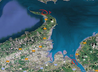
Location indicator shows Dorchester Cape on the map (Google Maps)

Location of the cliffs
The geology of the area is mostly formed of Upper Carboniferous rocks, and the location I was at is mostly Boss Point formation. The Boss Point formation is also found in Cape Enrage, Rockport, and Upper Joggins, to name a few places. The fossils that I find at the Dorchester Cape site is mostly discombobulate plant material, with dark grey to tan sandstones with some sandy conglomerate boulders lying about. Chunks of gypsum and some Albertite can be seen on the beach, as evaporites abound in the Albert Mines area, and some other unspecified locations in the Memramcook area. Albertite, and then gypsum, were an important part of the local economy, especially in Hillsborough across the river, as the geology of the surrounding area sees large deposits of various evaporites, a relic of the ancient Windsor Sea which would have receeded, giving way to vast forests and rivers.
But what was most important for Dorchester Cape was the copper found in the sedimentary rocks. This copper ore, chalcocite, was discovered in the late 1860s and mined until all operations came to a stop before the First Great War.

Dorchester Copper Mine. K. Vanderwolf. New Brunswick Museum.
From Memramcook, I drove down the 106 towards Dorchester. Once in the village, you take the 935, which is Cape Road, heading towards Dorchester Cape. The road turns into a dirt road about 2 clicks after the train tracks. Turn into the dirt road across the Atlantic Industries Limited business site. Make your way down the road, avoiding pot holes and man made roadblocks, and you'll eventually reach the old wharf.

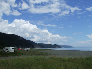
Make your way South (left of the wharf) and head towards the cliffs near Cole Point.


Looking back, view of Fort Folly Point slicing Shepody Bay.
As we get closer to the rock cliffs, you can already spot coal and petrified wood on the beach.

The plant fossils are mostly fragmented, showing signs of turbulence. There's some micro faulting in some places, and large sections of the cliffs are coming down in large segments.


Plastered with plants/tree parts (hat for scale)

The beach is littered with petrified wood, plant fossils, and chunks of coal.

Middle section replaced with orange calcite crystals

Some pieces are quite large (dirty hat for scale)

Common theme: plants sticking out to catch some Sun


One of the few holes where trees used to lie in situ


The cliffs have coal seams that can reach a few inches thick.


Tree imprint


Nice tree sticking out (squished hat for scale)


Close to the tree

NOT sand (chances of lithification?)
Disclaimer: In New Brunswick under the 'Heritage Conservation Act', fossils discovered must not be destroyed or removed from sites where they are found without a permit. It is every one's civic duty to report any finds to the New Brunswick Museum (https://www.nbm-mnb.ca/). This encourages the contribution these finds could make to science not just in the province, but on the global stage. You must also seek permission if you are to enter private land.

I enjoy your blog and photos. Here's hoping you have time and inclination to post more
ReplyDeleteThanks! Passion has always been there, even if it took a little break. Lots of exciting new things to share!
Delete