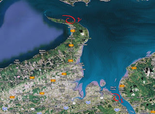
Tynemouth Creek (Gardner Creek)
I've been tallying up a list of new sites I wanted to visit and Tynemouth Creek was on the top of that list. The Tynemouth Creek coastlines, located in Southern New Brunswick between Saint Martins and Saint John, has been the site of newly discovered trackways which had been few before. The formations of this site are about Lower Pennsylvanian (Carboniferous) in age, with the occasional sliver of Pre-Cambrian rock crossing some of the local rock, and Triassic sections further East towards St. Martins.
Triassic cliffs at St. Martins
Driving there isn't too bad. From Moncton you drive towards Sussex, then head South through St Martins. I took the time to stop in town to check the beach and take a few pics before heading out. I wanted to go down the beach at Giffin Pond but access wasn't easy, so I turned back and made a quick stop at the light house to enjoy the scenery early in the morning.
I made it back to St Martins and continued on to Bains Corner, taking a side road South of there to Tynemouth Creek. Same thing here about access. I could have gone down but access wasn't easy to spot. This wasn't also the site I really wanted to check, so I hopped back in my car and headed West towards Gardner Creek.
Gardner Creek is kinda split in two where the bridge acts as the divider. The West section has these preserved, unaltered fossils and trackways from the Lower Carboniferous. The East section of these cliffs are more twisted, folder, and faulted, with Carboniferous formation slapped beside Triassic rocks, similarly found further East at St Martins.
I chose to walk the East section first. I immediately came upon stigmaria roots and other plant material. The further East I went, the less fossils I would find. Here's a few photos showing folding and faulting.
Mini fractures
Folding with smaller folds under the contact zone
The above pic shows the top strata, or rock layers, at an horizontal position, and the bottom section folded.
Exposed fold
Fault hidden from view (center), layers changing angle, and folding (far right)
West of the bridge at Gardner Creek, heading towards Wallace Beach, the sandstone yielded more fossils and trackways than the previous spot I went to. Most of the layers are not eroding at a fast pace, making the exposed trackways not so well detailed.
What's cool about these layers of sandstones are the calamites and other tree-like plants in situ, at a vertical position as they would have been when this place was a forest. The calamites are numerous and concentrated at certain spots.
Calamites in growth position
Calamites 'stumps'
Fern-like plant, very weathered
Arthropleura tracks
The pic above shows diplichnites, possibly made by a good size arthropleura (a kind of giant millipede). There were reports of some being found in this area and this slab had two sets of these tracks crossing each other.
The other set is not as well defined as the other set but you can still make out the direction.
Two sets are intersecting at the bottom
The site was very interesting and I wished I had stayed longer. Next visit I will have to explore further West towards Wallace Beach/McCoy Head, and attempt to check the cliffs directly at Tynemouth Creek and/or Giffin Pond.
That's it! Till next time!
- Keenan
Disclaimer: In New Brunswick under the 'Heritage Conservation Act', fossils discovered must not be destroyed or removed from sites where they are found without a permit. It is every one's civic duty to report any finds to the New Brunswick Museum (https://www.nbm-mnb.ca/). This encourages the contribution these finds could make to science not just in the province, but on the global stage. You must also seek permission if you are to enter private land.


