Geology Field Work of the Cape Enrage Area [2012]
Back in September 2011, I went on a field trip with my friend Matt Stimson and Dr. Randall Miller in the Cape Enrage area. The area wasn't well studied, so we walked the beach and inspected the cliffs. By the time we were done our walk that day, we had come across numerous geological features not previously recorded, and many fossil trackways to add to New Brunswick fossil record. A few days after our trek, we headed back to the fossil locality and proceeded with the extraction of several trackways, which are now housed in Saint John for further studying and preparation.
You can follow these links to revisit previous posts on the 2011 field trip to the area:
Fossil Track Expedition in Southern NB [Part 1]
Fossil Track Expedition in Southern NB [Part 2]
In one weekend we were able to make a few additions to the trackway record. That also meant that this area was susceptible to have more of them hidden along this stretch of alternating strata. The location was worthy of study, and could potentially help in filling gaps in New Brunswick's rich geological past, if not on the global geological level. Spring 2012 was a very warm season and beach access was pretty good. Matt had the idea of going back and make a thorough inspection of the area and perhaps write up a paper on the local. I can tell you that at this moment that this is becoming reality as Matt, with the help of myself and others, were able to collect data in a period of several months. A paper on the work we have been doing for Cape Enrage is in the works.

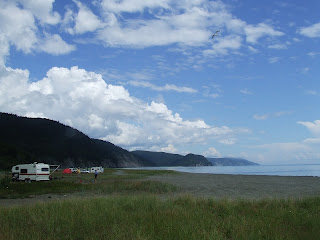
Trackways found the previous year (2011)
This post gives a summarized version of the work that had been done at Cape Enrage from April to July 2012, with a short geological history of the region and how it came to be.

Click on photo for larger version
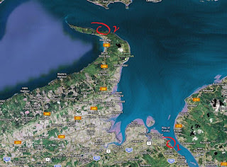
What we had planned was to record and collect data from the cliffs. At the same time we would take the opportunity to do the stratigraphy of the area, measuring a total distance of about 1.75 kilometers. This type of work would give us a detailed outlook on the progression of time by identifying the alternating strata, the composition, thickness, and any topographical features, some new or simply overlooked in the past by previous field work (if any). Such an endeavor gave us an in depth look at what the paleoenvironment at the Lower and Upper Carboniferous margin. Each visit to the site also meant the discovery and recovery of various trackways and specimens that have been collected and housed by the New Brunswick Museum at the present time.

Stratigraphy diagram (my interpretation of course)
Maritimes Basin (New Brunswick) and Cape Enrage
The Late Paleozoic Maritimes Basin, located on the Canadian East Coast, was formed due in principle to the weathering of the Appalachian Mountains (Acadian Orogeny). The basin (New Brunswick) is represented by thick accumulations of mainly sedimentary rocks deposited in various marine paleoenvironments (alluvial, fluvial, lacustrine, and marine). The site of study is situated within the Enrage Formation, which is in part a member of the Mabou Group, within the Cumberland Subbasin.
The rocks in this region are made up of reddish brown conglomerate, sandstone and mudstone, and with deposits of calcium carbonates. The sand goes from fine to very coarse, reddish orange arkosic grit, pebbly, and pretty much anything in between. The thickness of these deposits of the Mabou in New Brunswick ranges from 50 meters in sections where it lies over other age rocks to about 950 meters at its deepest. Individual sandstone beds are relatively thin (between 1 to 5 meters) and form repeated fining upward cycles from 4 to 10 meters thick. Fire brick red siltstone and mudstone form the upper layers (5 to 12 meters) of each fining upward cycle. Spotty buff and red coloration and reduction spheroids are commonly found. Calcrete nodules (mostly composed of calcium carbonates) and rooted zones are minimally present. Dark grey cherty carbonate laminations are locally a very distinct feature in the mudstones.
This Mabou Group mostly lies over the Early Carboniferous Windsor Group, or the Late Devonian to Early Carboniferous Sussex Group (or earlier rocks). The Enragé Formation is restricted to the Cumberland Subbasin geographically, occurring as two parallel belts on opposite limbs of the Maringouin Anticline, on the Maringouin Peninsula (Westmorland County). It strikes across Cumberland Basin to the Joggins area, where it is well-exposed along the shore near Downing Cove, Cumberland County, Nova Scotia.
The Enragé Formation is a mirror image of the Claremont Formation exposed on the shore of Cumberland Basin in Nova Scotia. It lies marginally over the Shepody Formation at a gradient angle, with extra-basinal clasts increasing in abundance upwards into the Enragé. It was first thought that the contact with he overlying Late Carboniferous Boss Point Formation was gradient because the contact was placed at the base of the lowest grey sandstone or quartz pebble conglomerate bed within the formation. It was at a later date placed in the upper contact of the Enragé at a much lower stratigraphic level, and suggested it was disconformably overlain by the Boss Point Formation. This is still being debated. The Enragé is also thought to be equivalent to the Hopewell Cape Formation. Both formations occupy the stratigraphic interval immediately below the Cumberland Group.
There is still debate on the age of the Carboniferous rocks in the Enrage Formation. Some believed that, with the study of some spore assemblages, they were able to pinpoint the age to the Upper Carboniferous Namurian, where others would put the Mabou Group in an age range from the late Visean to early Namurian, right in the transition period between the two. The age of the Mabou group could also be reasoned from its position, which also suggests an estimated age of late Visean to early Namurian.
To understand the local topography of the area or the Maritimes in general, I've taken the time to gather some information for the purpose of telling a story. I'll elaborate on this in the following section: A Brief description of the Carboniferous Maritimes Basin. After that section, I'll be segmenting the field work into five parts, which I'll be linking to different posts. Some sections have been written in my words, some have been taken directly from these sources.
A 'brief' description of the Carboniferous Maritimes Basin
This chapter deals with the geological history of the Maritimes Basin throughout the Carboniferous Period (Lower to Upper). The goal is to give the reader as close of a complete picture possible of what transpired to shape this section of Canada during the end of the formation of the Acadian (Alleghenian) orogeny to the great drying of the end of the Carboniferous (early Permian).
In the beginning...
The closure of the Iapetus and Rheic oceans, and the consequent plate collisions, resulted in mountain ranges along what is now the eastern coast of North America, from Alabama in the southwest to Newfoundland in the northeast. The modern Appalachians are all that remains of these ancient mountains. Areas within the mountains slipped and subsided along many faults associated with the Cobequid-Chedabucto and other fault systems, producing small, deep basins.
What is a basin? A basin is part of the crust that sinks or 'subsides' to allow great thicknesses of sediment.
This mosaic of interconnected mountains and basins, collectively called the Maritime Basin, dominated the landscape of the Maritimes from the late Devonian to the Permian. Rivers, streams, and mudflows transported gravel, sand, and mud into the basins, gradually building up thick layers of sediment.
From about 365 to 340 million years ago (mya), in the latest Devonian to early Carboniferous, in the lowlands within the Maritimes Basin, there were extensive river systems. There were also deep lakes bordered by deltas (alluvial fans) formed from sands and gravels washed down in mountain streams. Microscopic algae thrived in the lakes, and their remains formed thick layers of organic ooze on the lake bottoms. After burial and over time, this ooze produced "oil shales", such as the Albert shales of Southern New Brunswick. The oil shales are also rich in fossils of some of the earliest fish.
A great transformation of the Maritime landscape too place about 340 mya. The climate was becoming drier as the continents came together to form the supercontinent Pangea (Pangaea). The region that was to become the Maritimes lay within Pangea, at or near the equator. Surrounding Pangea was a huge ocean, the Panthalassic. Sea water began to invade the deeper, subsiding depressions in the Maritimes Basin. Eventually the sea covered all but the mountainous highland regions.
This ancient body of salt water is called the Windsor Sea, after the Windsor area of Nova Scotia, which is underlain by sedimentary rocks formed on the sea's floor.
Sea level rose and fell periodically during the 15 million years that the Windsor Sea existed in the Maritimes Basin. We know this from the repeating record of carbonates, evaporites (such as gypsum, rock salt, and potash), and "red beds" (such as shales, sandstones, and conglomerates). These cyclical changes reflect changes in climate between more and less arid intervals, which in turn may have been caused by the periodic expansion and shrinkage of a huge ice cap over the South Pole, far to the south of the tropical Maritimes. In many areas, the climate was at its most arid when sea level fell and water retreated from the continent.
Life in the Windsor Sea was similar to that in modern shallow tropical seas. In places, the sea floor shallowed into limey banks built up by colonies of corals, sponges, and lacy bryozoa. The warm waters above these banks were home to brachiopods, snails, bivalves, and a variety of coiled and conical nautiloids. Surprisingly, the record of fish from the Windsor Sea is sparse.
After the Windsor Sea retreated, red sandstones, shales, and conglomerates accumulated beneath the tropical sun, where once the sea had been. The rusty color of these "red beds" is due to the oxidation of iron during alternating wet and dry conditions, showing that these sediments were deposited on land, rather than in the sea. The climate remained hot, with long periods of drought, and was too harsh for lush vegetation. Deeper and more hospitable lakes developed along the line of the Copequid-Chedabucto Fault System in Northern Nova Scotia. Amphibians left their traces along the lake shores. As the global dance of the continents slowly changed the climate, rainfall increased, and the harsh, arid landscape began to turn green.
The late Carboniferous kicked in at 325 million years ago. The Maritime provinces straddled the equator, but were inching their way northward as the continents continued to assemble. Far to the south, the waxings and wanings of the polar ice cap continued to raise and lower global sea levels, just as they had during the time of the Windsor Sea.
This region, now completely emerged from the Windsor Sea, was crossed by northeasterly flowing rivers. The Appalachian Mountains were being thrust upward by the slow, relentless collision of tectonic plates, a collision that had begun over 100 million years earlier in the Ordovician and was now approaching its final phase.
Between the mountain ranges, extensive rainforest, swamps, and bogs flourished across the tropical lowlands of the Maritimes Basin as the climate grew more humid. It was in these swamps and bogs that coal formed. In the Maritimes, basins were subsiding and being filled by repeated sequences of coal seams, floodplain mudstones, lake or marine limestones and river beds sandstones. These repeating sequences, known as "cyclothems" (repeating sequences that record climate and sea level changes and migrating river systems) are seen in the exposed cliffs of the Cape Enrage area, in New Brunswick.
At the margins of the basins, adjacent to highland ranges, alluvial fans of coarser clastic sediments accumulated. Here, upland streams were checked in their progress and so deposited their coarse sand and gravel load. This might have been due to cyclic variations in the Earth's orbit, which would have been an important driving force of climate change throughout geological time, giving rise to prolonged wt and dry spells tens of thousands to hundreds of thousands of years long.
Under the influence of these climatic cycles, ice periodically melted rapidly over large areas far to the south. This added enormous volumes of water to the oceans and temporarily raised sea level by many tens of meters. The rising sea levels would have backed up river drainage, and bodies of brackish (partly salty) water submerged large parts of the Maritimes Basin, including the forested peat lands.
Brackish water suited neither typical freshwater nor typical marine species, but a variety of 'opportunistic' creatures took advantage of these difficult conditions, such as tiny clams and some sharks. Fossils of these creatures are preserved in dark, shelly limestones and shales that sometimes overlie the coals. When the great southern ice sheets began to expand again, large amounts of wate3r were once more "locked up" as ice, and sea level fell. Rivers flowed to the retreating sea across emerging coastal plains that were, again, being colonized by peat-forming vegetation. In the ensuing millions of years, the peat was converted to coal and the overlying sand to sandstone.
Life
Plants of the carboniferous coal swamps seemed strange to us, as most plants bore spores rather than pollen. There were no flowers or grass. Clubmoss trees towered unbranching to heights of 40 meters or more, such as lycopsids. Calamites, with its jointed, bamboo-like stems, is one of the few Carboniferous trees with a closely related present-day survivor: the horsetail.
There were also seed ferns, a group of plants now extinct, which looked like true ferns but multiplied by producing seeds rather than spores. Other plants clung to the ground or climbed, vine-like, on the trees. The ancestral conifer Cordaites was unusual for the time because it bore both pollen and seeds.
The coal-swamp environment nurtures some of the earliest amniotes, reptiles, and land snails, as well as gigantic insects. Arthropleurida, giant centipedes, could reach lengths of two meters. Some of its fossil trackways could be seen winding across long-past flood plains, showing that it lived mainly on the forest floor amid the trunks of towering clubmosses.
Some of the earliest known reptiles wre discovered in the Coal Age forests of the Maritimes. Sir Charles Lyell and John William Dawson i the 1850s found many specimens, including the earliest known reptile: Hylonomus lyelli.
Near the end of the Carboniferous
The brick-red rocks of Prince Edward Island and the Northumberland Strait shores of New Brunswick and Nova Scotia are evidence of a great drying episode that heralded the end of the Coal Age, towards the end of the Carboniferous. During this time, the Maritimes were still located within the supercontinent Pangea, which straddled the tropics. Hot air rose from this huge land mass that lay, baking, under the tropical sun. To replace this rising air, moist air was pulled in from the vast surrounding Panthalassic ocean, or dry air was drawn from across the continent. The resulting climate of alternating wet and dry seasons has been described as a "megamonsoon".
The Maritimes endured hot, arid conditions for several months each year, before the return of the monsoon rains. The persistent dry season spelled the end of the luxuriant wetland forests that had flourished in the Carboniferous. It also brought to a close the formation of peat in the Maritimes, needed to make coal.
The peat-forming ecosystems of the Coal Age collapsed and eventually disappeared.
I'm hoping this light reading helped to give you an idea of what the topography and stratigraphy of the Maritimes consists of. By knowing the background story, you're equipped with tools that can help you better understand your surroundings. I've had my training on the fly, which led to seek more information after the brunt work was done by opening some books and looking up papers.
The field work done at Cape Enrage in 2012 was done in a series of visits to the beach. I posted at the bottom links that will take you to each day of field work done at various dates from April to July 2012. I'm doing this to minimize space on one blog post and to make directly and immediately accessible the pictures taken during those visits, which I'm sure is what interests most people who'll come here.
Blog Post Links (click on the underlined link to access these posts):
Part 1: April 29th
Part 2: May 5th
Part 3: May 26th
Part 4: June 9th
Part 5: July 7th
(All pictures and/or diagrams on this post are for educational purposes only. Copyrights to their respective owner(s) should be respected.)
Disclaimer: In New Brunswick under the 'Heritage Conservation Act', fossils discovered must not be destroyed or removed from sites where they are found without a permit. It is every one's civic duty to report any finds to the New Brunswick Museum (https://www.nbm-mnb.ca/). This encourages the contribution these finds could make to science not just in the province, but on the global stage. You must also seek permission if you are to enter private land.