2012: A New Year of Rock Hunting... That Started REALLY Early

Happy New Year! As time progresses, the finds and fun gets better and Mother Earth keeps on giving. I celebrated 2012 by going rock hunting, in January! We've had record highs in warm temperatures in the Maritimes so I grabbed the opportunity by the horns and headed down by Johnson Mills (Cape Maringouin) to test out my newly acquired field GPS.

Surprisingly, for January 2nd, there was no snow on the ground. There were traces of ice around pools and other bodies of water, but not much to give you clues that we were smack in the middle of Winter. The other thing too is that it was a comfortable 7 degrees Celcius, which has to be a record high. Driving on the dirt road felt like driving on ice, as the car kept zigzagging all over the place.
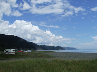
By the time I got there, I had reached low tide. I had brought my Tiley hat and raincoat as there was possible rain in the afternoon forecast. Camera in hand, I ventured down the road and onto the icy beach.

When I got on the beach, I looked at my watch and set myself a goal: walk as far South until my watch hits 1:30PM. I got there at around 12, so I was curious how far down I would make. My intention was to go down there, take the GPS coordinate of the position, turn around and make my way back by taking additional coordinates with visual references (photos). I would use that data afterwards to see how it would reflect on topo maps. This is all for personal use.

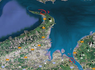
The map above shows the multiple GPS coordinates I took along the way, with the lowest coordinate, 'I', being the furthest South. I didn't find anything that popped out. There were some locations that showed biomass, and other spots with potential for finding fossil tracks. The weather had turned to shitty weather by the time I got to my first coordinate. Rain started to fall and it got very dark, dampering my search for trackways. Nonetheless, I took a few pics.

Location 'I' - N 45 46 42.71, W 64 30 45.34
Location 'I' was the furthest point I had reached that afternoon, about 3.5 kilometers from my car. Walking South I could see the cliffs starting to show exposed sandstone strata at different angles and showing different physical features. By the time I reached the last few hundred meters from the farthest point, the cliffs were caked with muck and mud, with the sandstone keeping to ground level, occasionally exposing strata in perpendicular sequences along the beach and into the bay. By the time I reached this spot, the clouds became very dark and it started raining pretty hard.

Location 'II' - N 45 47 08.09, W 64 30 22.14
This section of sandstone contained a lot of conglomerates compared to the first layers further North.

Location 'III' - N 45 47 17.22, W 64 30 16.64
Erosion at work! You can see the rain water trickling down from the top, carrying loose sediment down to the beach. This type of hydroactivity, including the effects caused by tides, show the result of what happens to sandstone in the picture above. Another feature visible is the different strata of sandstone, mudstone, till composing the cliff, at a slight angle. You get to see fossilized biota, especially around the greyish colored mudstone.

Location 'IV' - N 45 47 26.83, W 64 30 15.54
Occasionally you'll get interesting features like this one. The prominent sandstone stratum located on the left appears to be lifting upward, while another section continues a few feet after a gap of a few feet, onto its original plane. The mudstone layers directly underneath that odd sandstone stratum seem to be following the same flow, curving then changing back to a quasi-horizontal position.

Location 'V' - N 45 47 40.98, W 64 30 09.64

Location 'VI' - N 45 47 43.34, W 64 30 07.66
The grey area in the picture above shows sediment containing some fossil material.

With the warmer than usualy type of weather, the ice melted and found its way down multiple places along the cliffs, creating beautiful ice waterfalls. Crossing them was a bit tricky, especially when you slip and get your freakin' boots wet.

Location 'VII' - N 45 47 47.87, W 64 30 02.26
It ended being a nice walk. By the time I reached the last location, the Sun had come out and it was really getting warmer. Really glad that my GPS turned out to work better than I expected. Thanks to my folks for a great gift!
Now that I have an idea of distance and time it took to reach the goal I set, next time I intend to find a way to make my way all the way South to an inclosed beach that's almost impossible to reach. There are two ways to reach it, and I'll assesss the situation when the time comes: either by a shorter route via the beach by the Johnson's Mills bend, or through the woods via the Lower Rockport road that passes Slacks Cove and eventually turns into a woodlot. All in all, it'll be quite a challenge.
Till next time!
Disclaimer: In New Brunswick under the 'Heritage Conservation Act', fossils discovered must not be destroyed or removed from sites where they are found without a permit. It is every one's civic duty to report any finds to the New Brunswick Museum (https://www.nbm-mnb.ca/). This encourages the contribution these finds could make to science not just in the province, but on the global stage. You must also seek permission if you are to enter private land.