Ram's Head / West Bay (Diligent River, Nova Scotia)
I've been looking for this little trip for quite a long time, since last year actually. When I was doing some digging up about important geological sites related to fossils, and Diligent River was on top of my list. The area has be known to have a good record of trace fossils (ichnofossils) of animals that roam the area in the Carboniferous Period (between 320 and 280 million years ago) when this was a wet swampy forest. The other reason for me to go fossil hunting in that spot is ferns.. ferns ferns ferns.
I was gonna go on my own at one point but I'm happy that the Fundy Geological Museum (FGM) had organized a curatorial walk of Ram's Head in Diligent River. Here's an exerpt from their website:
The rocks of Ram’s Head-West Bay tell of the warm tropical coal swamps, rivers and shallow lakes that existed during the formation of Pangea before the beginning of the age of dinosaurs. This area has some of the most spectacular exposures of amphibian track ways to be found in the Parrsboro area.
- FGM Curatorial Walks

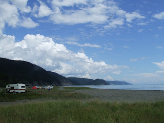
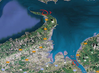
Diligent River is about a 15 min drive from Parrsboro, on Route 209 heading West. The most straight forward way to get there avoiding as much dirt road along the way is by driving down Ramshead River Road in Diligent River. You drive South until you come up to a 90 degree bend. Continue on the narrow dirt road until you reach the wharf.

I arrived in Parrsboro at about noon, but the tour was only starting at 1:30pm, so after my turkey sandwich at the Gloosecap Family Restaurant, I had a bit of time to myself. So I decided to swing by Two Islands real quick for a little walk before heading back to the FGM.

When I went down the trail and hopped on the beach close to Wasson Bluff, it felt a little bit chilly. The fog hadn't fully lifted yet. I proceeded East instead of West as I had never walked in that direction before.

"Two Brothers"
I walked for about 20 minutes and before I knew it, it was time to turn back. The cliffs from the trail I took to get down to the beach to this point showed clay and glacial till being eroded. I saw some layers of sandstone under all that loose sediment. I'm told that if I'd walk a bit further, I would have have started to notice the cliffs changing to basalt. Walking back and up that trail made me built a sweat. I was happy to sit in my car for the next few minutes.
I drove back to the FGM and we gathered our tiny group to head out to Ram's Head. The group consisted of myself, Ken Adams with his family, Andrew from the FGM, and a couple from New York.

**Important**
Bring a change of footwear. You have to cross a shallow body of water to get to the cliffs. I didn't but I didn't mind getting my feet wet. The drive home though was a bit tad uncomfortable, so I will bring my Teva sandals next time (I SHOULD have them in the trunk of my car all the time).
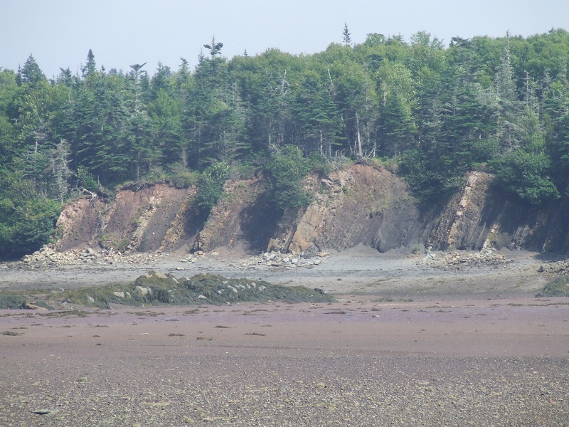
These are cliffs that are located close by South-East before crossing the dune and hiting the beach. The cliffs along the beach are similar to these. Trace fossils and other plant material have been found in these cliffs recently. I'll have to come back and check them out.

Ken and Andrew headed towards Ramshead Point
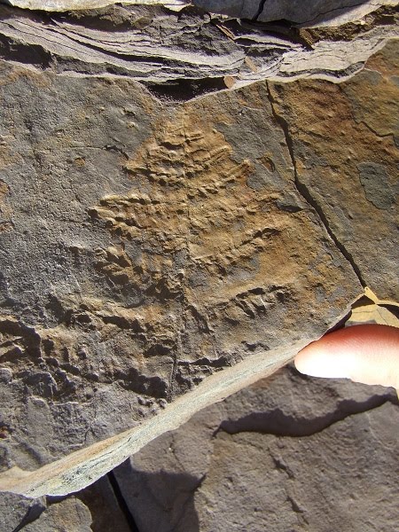
I turned this pic upside down as the original fossil points down. This is one of many ferns found in the shale along the beach.

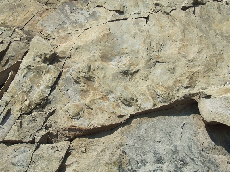
Fossil Tracks (direction: heading left)
Set of fossil tracks, or ichnofossil(s), found early on our walk. The afternoon Sun was nice as it helped project shadows at angles where it was easier to distinguish forms on the sedimentary cliffs. Good indicators for possible tracks? Sandstone featuring ripple marks or growth, such as ferns (from what kept coming up with most of the tracks we spotted).
Another set of tracks

Unusual cliff feature (of glacial origin?)

Not all tracks or physical profile was made by animals. There are for example holes with U-shaped features around it. I suppose that could be objects, such as plants, causing sediment to accumulate on one side. The picture above shows what was once a tree, possibly from the lychopsid family, standing at an upright position. The strata was turned and resting in its current angle due to tectonic activity and the pushing and tugging caused by continental drifting. This was a time when the supercontinent Pangaea was being pulled apart. It had formed during the Paleozoic Era, when paleocontinents collided together to form this giant mass. These cliffs were layed down over millions of years during the Carboniferous (Lower?). Pangaea was then pulled apart during the Mesozoic ("Age of the Dinosaurs"), creating other supercontinents such as Laurentia and Gondwana, creating the chain of events that would lead to the modern shapes the continents have today.

The further you walk East, the more you see folding. The folding is more apparent further when you get close to Ramshead Point and the stratum takes on a different angle.

Tracks?


Fern
The ferns found in the shale are beautiful and very detailed, but the sedimentary rock is very brittle.


Slip(?)

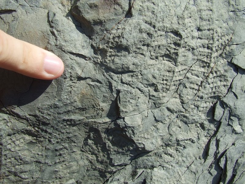
More tracks, and these are very nice. The sandstone shows different other textures and features. These dozen footprints or so seem to be indicating that the animal was walking from right to left, and at one point undecidedly turning left. Possible body drag, but I'm not familiar with these yet to fully recognize them.

General direction of animal's trajectory


Close up

Another set of beautifully detailed footprints. These could be seen at a good distance. There's about 16, possibly 17, footprints that can be seen. The sandstone layer on top of it might very well be obscuring additional tracks from the same animal.

Set of footprints

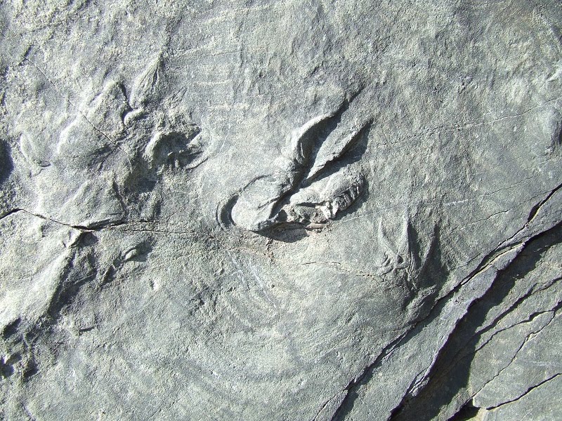
The picture above showcases about half a dozen footprints. So far I could makeout a four-toed animal, but the impression doesn't always tell the whole story. Some elevated impressions show some footprints with extended features, such as fingers, and some others show what could just be the ball of their feet. The impression here is that the animal might have been walking with its feet directed inward, like a low bodied animal such as a crocodile would, twisting while it walks.

General direction and trajectory of animal

Closeup of toed footprint

The rightmost footprint shows what seems to be 'twisting', when the foot is down in the loose sediment, such as sand, changing direction while lifting it while moving forward (these are my personal observations of course).

These are another set of tracks showing details such as fingers, located just above the linear cavity. These two lines of footprints line up, and seem to be showing the animal moving from bottom left to top right.

Set of footprints that show some potential 'toe drag'. Some individual prints show the fingerlike features to be extended, as if dragged for a little distance.

There were a lot of close-calls and this one was tough to tell if it was or wasn't a trace fossil. There were many that could be, but just was too chard to tell, so we didn't consider as tracks. Can you find the supposed footprint in the above photo?

As I was saying before, the folding becomes more drastic the further East, and eventually the layers are set in a different angle than the ones we first encountered where we started our walk.

Sometimes you will find deer walking along the beach. I had seen some at Five Islands Provincial Park. Some find ways down by finding a trail, some by falling down. This was the size of a faun, and it wasn't able to find its way back up. I've seen dead seals before, where the head was cleaned off of flesh, but the rest of the body was intact, but my first encounter with a dead deer. Poor young feller.

"Cape Split"

Our walk back..
This was a wonderful spot, especially if you love looking for tracks. I wasn't disappointed. Some of the pictures of the footprints might be the last time that anyone will see, as the cliffs erode and weather at a very fast pace and the rate of how the cliffs get defaced by the hydroactivity and wind makes it even more unpredictable. But with this type of change can reveal more surprises. Next time I'll remember to bring an extra change of footwear.
Cheers!
Disclaimer: In Nova Scotia under the 'Special Places Protection Act', fossils cannot be dug up or disturbed without a permit. The province has a mandate to protect palaeontological sites and it is your civic duty to report any finds to the local museum, or the Department of Communities, Culture and Heritage (https://cch.novascotia.ca/exploring-our-past/special-places). This encourages the contribution these finds could make to science not just in the provice, but on the global stage. You must also seek permission if you are to enter private land.