Arisaig (Arasaig), Nova Scotia
Oh Arisaig, how I've longed to go visit ye!
I've been wanting to go visit Arisaig Provincial Park when I first compiled a list of sites to visit in Nova Scotia. Arisaig is on top of that list due to the importance of the fossils found there. It is said that the Silurian age rock outcrops in the Arisaig area are one of the best in the world. They give a good picture and interpretation into the paleoenvironment of that period.

Environment during the Silurian Period (~443 to 417 million years ago)
The Silurian Period that mostly saw life in water, from about 443 to 417 million years ago. Life stuck in the ocean and other bodies of water, as the surface was not inviting. Only a few tiny plants started to make the surface their home.
The environment in the seas and oceans of the Silurian would have been seen a diverse and abundant in animals such as early fish, trilobites, snails, molluscs (bivalves, brachiopods), crinoids (sea lilies), nautiloids, and many other genera. Most of these animals would have lived at the bottom of the sea floor or burrowing in the sand or silt. Some would have crawled and left traces, while others swam. The rich deposits of fossils at Arisaig give us a picture of a paleoenvironment that was abundant in the necessities of life for these organisms: food, oxygen, and sunlight. Sedimentary structures such as sand waves can be found, meaning that this type of environment would have been an open continental shelf with low water depths. Turbulent weather, like storms, would have helped shape the sea floor.

(illustration taken from brochure, NS Museum of Natural History)
You can click on this link < here > to find out more about the different species that made these seas their home.

Arisaig is a ways away from Moncton, about 270 kilometers. Which can take anywhere between 3 and 3.5 hours to reach, depending on which road you take. You could take the TransCanada highway 104 from Amherst to Truro, then continuing on to Stellarton and up the 345 to Arisaig, but that's boring drive. I opted instead to take the coastal road from Amherst to Tatamagouche, then onward to New Glasgow to get to Arisaig. It took me about 3.5 hours of driving time to get there, but well worth the drive!

Windsor Salt Mine (Pugwash, Nova Scotia)
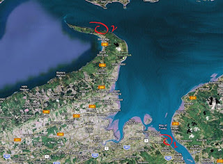
After a few short stops along the way, and a few minor detours, I managed to reach Arisaig Provincial Park. The park is located before the wharf at Arisaig Point, coming from New Glasgow way. You can either park at the entrance or drive further in to the other parking lot.

Trails are nice and maintained

Trails going down to the beach
Before going down the beach, you can stop at the picnic tables under the covered hut. They installed some neat interpretive panels with information on Arisaig's paleoenvironment and geography.


Map of the park

Visual interpretation of Arisaig's environment during the Silurian
After the picnic tables, you can take the trail down to the shore. The trails split in two places, both with access to the beach. The trail East was a bit tricky to go down as the steps going down were not there due to construction. It wasn't too far down so I managed to make my way safely.

View of the West steps from the East steps
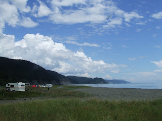
The scenery is pretty cool once you hit the sand. When you face the ocean, on the right you see this:

.. and when you look on your left, you see this:

The fossil bearing cliffs are along the West side of the park, towards McAras Brook. On the East side towards Arisaig Point, the topography changes and you get rhyolitic and basaltic rocks from the Ordovician period, mostly devoid of fossils. I didn't get the chance to check those cliffs as they might be bearing minerals, but I'll make it an item on my 'to do' list next time I come visit.

Exposed outcrop of mudstone and siltstone (Arisaig Group)
The cliffs where I was standing at, and all the way to the wharf, are poor in fossils, if any. You need to walk a couple of meters before reaching the fossil deposits. The layers are tilted at about 25 degrees, but vary along the 5 kilometer stretch West. The zone closest to the wharf show signs of work with folds and other features. You can also see the presence left by the last great iceflows from the last ice age, that disappeared about 10,000 years ago. That period of upheaval and receeding ice deposited glacial till, seen at the top of the cliffs.

Tilted layers of siltstone and mudstone

Distinct layer of glacial till (top)
After a few minutes of walking I get to my first fossil bearing outcrop. The cliffs are a mix of alternating strata of undulatory sandstone and siltstone/mudstone. The outcrops stretch to the floor for a few meters at some places. The sandstone seem to interpret a calmer environment than the other type of sedimentary layers.

It was tough for me to find the fossils at first. I wasn't sure how to check or how to approach and find anything. I took some time to eyeball some layers and in no time I found my first brachiopod.

First!
Brachiopods are a little different than normal clams (bivalves). They have two shells, but they're not of the same shape. From what I've seen, they're the most common found here in Arisaig.

The examples that you get are very nice indeed, but keeping them together can be a bit challenging as silt can easily break apart in your hands if you're not careful. Extra care should be taken when handling these.


The next few photos are what you mostly see from the outcrops jutting out from the cliffs, when you make your way towards McAras Brook. You can see the alternating layers of sediments, the kinks and breaks in the cliffs due to tectonic activity at one time or another, and the layering of different depositional sediments influenced by current environmental events.


Fossil bearing sandstone


At this point, the fossils just kept on popping from everywhere. I was surprised at how detailed and well preserved these fossils were in this kind of exposure. Other types of fossils would show up, such as graptolites, crinoids (stem), nautiloids, and fish remains (small bones, scales).


The sandstone layers are also fossil rich. Details vary depending on the layer you're looking at. In the picture above, the fossils are located where the photo scale is.

I was there for only a few hours, but for the short time I spent it was well worth the drive to Arisaig. That corner of Nova Scotia is just amazing. I know that if I'd spent more time scratching and sniffing around, I'd find trace fossils or trilobite bits.
I hope to be able to head out again later this year. The next time I swing that way, I'll venture North on the other side of Arisaig Point where the topography changes to volcanic rock, some of the oldest rocks in the area. We'll have to see about that.
Disclaimer: In Nova Scotia under the 'Special Places Protection Act', fossils cannot be dug up or disturbed without a permit. The province has a mandate to protect palaeontological sites and it is your civic duty to report any finds to the local museum, or the Department of Communities, Culture and Heritage (https://cch.novascotia.ca/exploring-our-past/special-places). This encourages the contribution these finds could make to science not just in the provice, but on the global stage. You must also seek permission if you are to enter private land.