Fossil Track Expidition in Southern NB [Part 1]
A while back I had posted [here] that I had partaken in a field trip in Southern New Brunswick. Me and my buddy Craig had planned to go on a trip to Parrsboro (Friday, September 9th 2011). That morning I had received an email from my friend Matt about going on a field trip in the Cape Enrage area to investigate the cliffs over there. If we decided to go, I would have the chance to meet Dr. Randall Miller, the current curator of the New Brunswick Museum. We agreed to modify our plans and contacted Matt. After picking up Matt and some morning grub, we proceeded South towards Fundy.

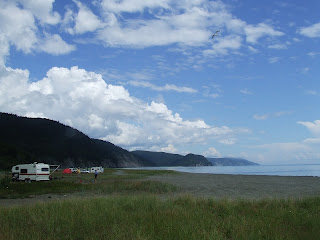
Our destination was a beach in the Cape Enrage area. To get there we had to drive down a short dirt road off the main road, not too far from the Cape Enrage Interpretation Center. I'm not gonna give the exact location as the site itself has yet to be checked thoroughly, and the old man that lives close by on this dirt road isn't too fond of strangers from what I'm told. Driving up to the beach we saw Dr. Miller's car already parked. We stepped out of the car, got some basic gear with us and proceeded down the beach to meet up with him.

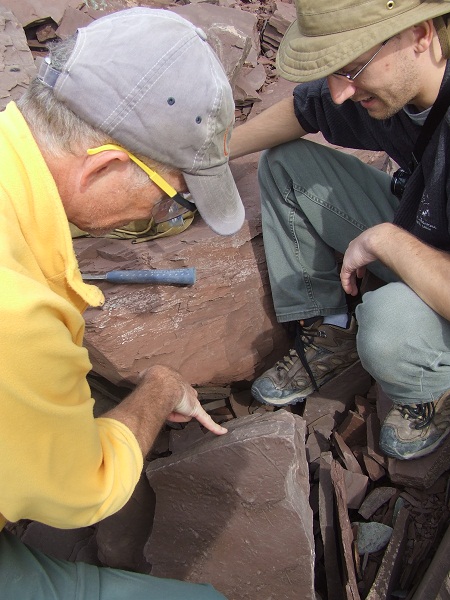
Craig inspecting the cliff up close
This location has some of the most beautiful sandstone formations I've yet seen so far in this area. The sandstone color and grain doesn't match the type you'd see at Cape Enrage. These cliffs are Carboniferous in age. There's a fault not far West of our location. Rather than the typical grayish, granular, and coarse sandstone of Cape Enrage (Boss Point Group), you get these red, fine to very fine sandstone. Walking South-East along the beach the sandstone eventually changes to the familiar, quartz-like sandstone. The cliffs from what I can understand, are part of the Mabou Group: the Maringouin formation (reddish sandstone, similar to Johnson's Mills in Dorchester Cape), and Shepody formation (the greyish, coarser grain). If you'd continue further East, the sandstone would get coarser and take a greyer tint, and some pink, with quartzite). You'd run into the Enrage formation, and then Carboniferous Boss Point Group formations, at the tip of Cape Enrage.
This information can also not be that accurate. The geological survey of the province, especially in these parts, wasn't probably done to the expected degree. It could be that the formations don't necessarily reside in those exact demarcations as we speak. The age of some of the rocks could possibly vary from previous assessments, but I'm no professional geologist so I couldn't tell ya!

Matt (left) and Dr. Miller (right) observing sandstone featuring ripple marks
The purpose of this trip is to see if we could locate ichnofossils, fossil trackways left by animals a long time ago. In Nova Scotia, trackways are found in many areas. In New Brunswick, its a different story. At best, the province has recorded less then a dozen trackways in a period of 150 years. If there were more, they just weren't reported, or identified as trackways to the untrained eye. The chance to find trackways to add to the short list would be a great addition, and knowing that I would have contributed in their find would be icing on the cake.

It didn't take long before we came upon our first set of tracks. The sandstone slab had broken apart from a bigger layer at a height of at least 15 meters, slid down the cliff and rested belly up, exposing multiple trackways and other features.

Two sets of tracks, split at the bottom (coin, also for proportion)

The sandstone slab, if I remember, measured about 4 meters (12 feet) in width, and approximately 5 feet in length. The slab also has a convex shape (bulging outward). The right side, viewing if if you're pointing North, shows several trackways, running somewhat perpendicular from each other, crossing path at the South end. Other tracks show up as less detailed the further you look left (westward). Reaching the top of the bulge, tool marks appear, running across the slab at a vertical angle. The tool marks were probably made by material, such as tree branches, dragging at the bottom of the channel. The surface that shows the tracks are also peppered with tiny water droplet features.

The figure above shows animals walking along a body of water, leaving tracks in the sand or mud. The plane then dips down to reveal the direction of the current, dragging material which scrapped the bottom along the way. The picture that I can conjure is an animal or several animals (manus/pes of different scale, direction) is of activity. Probably the best place to find animal activity is near a body of water, like the one we found. This was pretty cool indeed to catch animal movement in a setting, enjoying a stroll by the water.

Example of a tetrapod and its movement
These weren't the only trackways we were destined to find that day. The next find came up not too far from that first sandstone slab. on the cliff face were sets of very well elevated tetrapod tracks. From what Matt told me, they were part of a big set that basically crumbled away. The surface also shows weathering patterns caused possibly by water action (ie. rain).

Later that day we came up to some broken pieces of sandstone that had rolled down the cliff. The others noticed a piece of sandstone a few couple feet in diameter at an angle, displaying some linear feature. Upon closer inspection, this zigzag of a line was what seemed to be a tail drag!

Matt inspecting the newly found trackway
This trackway measuring almost 4 feet across, snaked the surface of the sandstone block. The tracks themselves weren't obvious from the get go, but the tail drag was a clear indication that this was made by a small animal a few inches long. The track displays the animal changing direction at one point. The chance to have found such a trackway was extremely exciting.

We cleaned the rubble around it and inspected other sandstone fragments in the close vicinity for other tracks. After a few minutes we made a mental note of where this track was located and proceeded further East in search of more.

Strata coming together

Water channel

At this point in our walk we noticed the sedimentary rock change color. Cape Enrage is located a few kilometers East, and this type of sandstone is what you'd find over there. We had walked into a different formation. We decided to turn around and head back.

Walking back we looked around for sandstone bearing similar surface features as the last trackway we had found that afternoon. We had found tracks of various sizes easily detectable to the eye from a distance. While we did find some nice trackways, we were also keeping an eye out for trackways that we would usually have passed over if not for inspecting up close the sandstone littering the beach.

This is the result of paying attention to minor details. Dr. Miller and Matt had come across a block where the surface showed small, very faint lines running parallel to each other. Hermit crabs, to my knowledge, don't leave trackways of this type. At this stage nobody in our group could positively identify these diminutive tracks. They agreed that the best thing they could do, given the size of the block, is to try to extract it from the beach.
**NOTICE**
Extracting trackways or fossils, important such as these ones, are legal only if you have a permit to do so by the Province of New Brunswick. Luck today, we had Dr. Miller who is the sole authority in the province when it comes to these issuing these permits. Legalities aside, we endeavored to skim off the excess matrix from the sandstone block to make it easier to carry.
Inspecting the favorable spots to chisel

Chiseling away the excess 'fat'
On our walk back we stopped at the last trackway we came across to take detailed pictures. Given the size of the chunk of sandstone the trackway was laying on, extraction would at this point seem quasi-impossible.


Geologists are part human, part spider monkey

After taking notes of the finds today, came the dilemma of what to do with these. We all talked about how these tracks would be nice additions to the scientific community. The more we discussed it, the more we came to the realization that we had to try to extract these bigger trackways off the beach for research and record. Dr. Miller wouldn't be available as he had to leave for Norway on conferences. I suggested to Matt that we could come in two days and try to extract at least one set of trackway, and create a plaster cast of the other. We all agreed that this was very important and that me and Matt would come back on Sunday for a little bit of field work. With the papers to make our job easier, we agreed to come back and try to remove these suckers, in the name of science of course. =)
That's it for Part 1 of this excursion. That day was the preliminary expedition to search and find worthy specimens and we were in great luck. Now the tough job was to try and extract if possible, or at least cast them if extraction deemed to troublesome. I mentioned to Matt that this was an amazing opportunity to be able to partake in professional field work. The other thing is that I would also be schooled on the basics of field work and sedimentology, both subjects I wanted to learn more. We agreed on time and location for Sunday and make the necessary preparations.
The rest in Part 2!
Cheers!
Disclaimer: In New Brunswick under the 'Heritage Conservation Act', fossils discovered must not be destroyed or removed from sites where they are found without a permit. It is every one's civic duty to report any finds to the New Brunswick Museum (https://www.nbm-mnb.ca/). This encourages the contribution these finds could make to science not just in the province, but on the global stage. You must also seek permission if you are to enter private land.

Comments
Post a Comment