Cape d'Or, Nova Scotia
Cape d'Or was on my list of 'Must See' sites in Nova Scotia. I've read and heard stories of the minerals that one could find in the basalt cliffs. Story goes that when voyagers arrived in the area by boat, they saw the cliffs glinting and thought it was gold. The real fact is that this wasn't gold, but (native) copper. The copper was mined by the Colonial Copper Company way back in the late 1890s to about 1905, but difficult times had fallen on the mine and eventually closed.

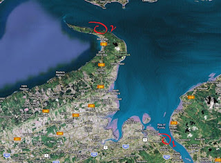
Cape d'Or (circled in red)
Me and my buddy Craig decided to head down Nova Scotia last Sunday (May 13th) to check the place out. We brought our tools just in case we'd drop on some goodies. Parrsboro is about 1 hour and 15 minutes drive from Moncton, New Brunswick. From Parrsboro, you take the 209 West towards Advocate Harbour and drive about 45Km. The road snakes into eccentric bends and turns, especially around Port Greville, but that's nothing compared to the Cape d'Or road. Cape d'Or Road is a dirt road rollercoaster. At some places the hills were so steep that my traction control on my car kicked in a few times.

Cape d'Or Lighthouse and restaurant
The view is breathtaking, even though the weather was kinda bleh. I had an idea that the cliffs were high but man, getting there and seeing the rock formations and basalt cliffs, I was taken aback. Even Craig who isn't usually afraid of heights felt a little bit nervous walking close to the ledge. The weather that day was good, and barely any wind. That is good as I wouldn't want to be around on a windy day, get thrown like a sack of potatoes off the cliffs is not good!

South East view of the coast from the lighthouse
(Cape Split seen in the background)
Usually the Advocate Harbour topography is made up of Carboniferous to Triassic sandstones, but from Cape Spencer all the way to the tip (continuing to Blomidon), the cliffs change to basalt. These basalt cliffs are left over lava from ancient volcanic activity from around the Triassic Period (North Mountain Formation). There might have been up to 6 different lava flows that had covered this area, leaving intriguing structures such as columnar basalt formations.

The sign should say 'Danger: Murderous Cliffs!'
The picture above doesn't really do justice when it comes to gauging the height of the cliffs. You have to go there to really take it in. I felt dizzy just standing around the lighthouse. There are some trails that take you around the lighthouse, and on the cliffs. Making it down can be VERY treacherous and you could easily hurt yourself.

Ile Haute (located South-West, about 20km)
Like I was saying, you can easily hurt yourself trying to get down to the 'beach'. If you do, then you'd have to be extremely weary of the tides, as you can easily be trapped and have no way of making your way back up. This is a thing to consider if that crosses your mind. Another cool feature of the cape lies in the water. The geography of the area causes whirlpools to appear. These are a testament of the workings of the currents, which are not to be trusted. We decided that at this point in our visit, it would be wise to stay on dry land and take in the scenery before heading back to Horseshoe Cove, located about 1.5Km from the lighthouse.

View looking East

View looking West

View looking South, South-East (Cape Split)

Columnar basalt

Critter the size of a cat

View of the cliffs on Advocate side, looking North
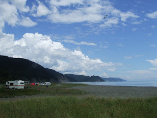
We hopped back in the car and drove about a mile back towards Horseshoe Cove. The cove would give us an easy access to the beach and a chance to look around for any minerals. The real goal was to check the cliffs towards the East, but at this stage with the tide, there was no way we were gonna chance it.

Surprisingly when we got there and snooped around a bit, we managed to find some stuff. The tidal action just does a number on those cliffs and all sorts of goodies are exposed, if you know where to look.

The cove is a little bit more sheltered from the elements and the tide takes a little bit longer to make its way in, so we decided to walk to the cliffs on the South side.

Pressed for time, we looked around a little and managed to find a few things. We brought some tools with us so we were able to bring with us a few samples from the area.


After a hour or so, we decided to call it quits and go back to Parrsboro to catch some grub. On our way out, we noticed glinting on the rock surface near the old wharf beside the trail leading up to the car. At closer inspection, it was a basketball-size pocket of quartz-like crystals, glinting like fresh snow. We took out our chisels and managed to get fair sized chunks of very fine crystals, which were already show worthy.

In the right light, these give off a nice glinting effect

There were a few things we wanted to do that day, but we'll postpone that for next time. All and all it was a very good road trip, and it only gave us a small taste of what to expect from Cape d'Or. Since the trip we've got more information and a better plan of attack. By then we'll also be able to come into contact with locals who are familiar with the lay of the land.
Looking forward to our next trip to Cape d'Or. Til' then, cheers!

Comments
Post a Comment